


Beaches of São Paulo: Guarujá, Ilhabela, Ubatuba
Below a summary with some of the most important beaches of the coast of the State of São Paulo.
Playa Asturias - Centro de Guarujá
photo by preit - CC 2.0 by-sa
Guarujá
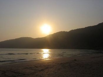
Atardecer en la playa de Guaiúba - Guarujá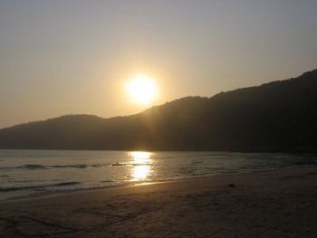
photo by brunabichara - CC 2.0 by
It is one of the main beaches in the state of São Paulo, and also one of the closest to the capital, which makes it an excellent seasonal tourist destination, a weekend getaway option for the inhabitants of the capital . It is on an island separated from the mainland by the Bertioga canal, but access from the capital is direct via the route, it is also possible to arrive via a raft from the coast of Santos .
Guarujá de Noche
photo by Jossian Brito - CC 2.0 by
Its main beach is Pitangueiras , urban beach of enormous movement, with all kinds of day and night attractions in bars and restaurants of all levels, opposite very close to the coast it has a rocky island called Ilha da Pombeva . This beach and Asturias , beach next to Pitangueiras , are completely surrounded by tall buildings.
Praia do Tombo - Guarujá
photo by Natureza2008 - CC 2.0 by
Going a little further north, crossing the Morro do Maluf you come to the Praia da Enseada ( See satellite map ), extensive and also quite urbanized but with low houses instead of buildings, this makes it more pleasant for those who hate the shadows on the beach that project the huge buildings of > Pitangueiras and Asturias.
Praia do Bonete - Ilhabela
photo by lgoose - CC 2.0 by-sa
Those looking for quieter beaches in Guarujá can choose the beaches of Guaiúba ( View on satellite map ), about 5 kilometers south of Pitangeiras , or the beach Pernambuco ( See in satellite map ), a small inlet delimited by 2 hills that is about 10 kilometers to the north going along the coastal avenues.
Playa de Ubatumirim - Ubatuba
photo by felipefonseca - CC 2.0 by-sa
See how to get to Guarujá
See map of Guarujá
Gruta en Praia da Sununga - Ubatuba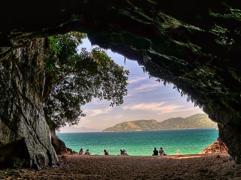
photo by Rafael Vianna Croffi - CC 2.0 by
Ilhabela
Praia do Lazaro - Ubatuba
photo by sziliotti - CC 2.0 by-sa
This huge mountainous island 210 kilometers east of São Paulo, is similar in lush geographic attractions to & nbsp; Ilha Grande in the state of Rio de Janeiro, it is reached by rafting(ferry) from the city of São Sebastião ( See satellite map ), the ferry crossing to Ilhabela takes about 20 minutes.
The part facing the continent is the most urbanized, with infrastructure and road connections, on the side facing the Atlantic. Deserted beaches and spectacular landscapes are only accessible by paths: mountain, waterfalls, sea and lush tropical vegetation; a true paradise of ecological trails. The beautiful beach of do Bonete stands out on that side of the island( View on satellite map ), in which there is a small fishing village; access is via boat u, option only for the more adventurous, 4 hours of hiking trails through the mountains.
Another beautiful beach is the beach of Jabaquara ( View on satellite map ), this beach is more close to the urban part of Ilhabela, and accessible by car through a dirt road bordering the sea.
A very interesting ride is the one that is made in all-terrain vehicles, crossing the island in half until the Baia dos Castelhanos ( See on satellite map ), the route goes along barely passable paths, going up and down the mountains, in the middle of wild nature.
The wind of the northern part of the island makes it one of the best places for water sports such as windsurfing and kite surfing.
Other attractions of the island is diving, due to the occurrence of several shipwrecks in its waters.
See how to get to Ilhabela
See map of Ilhabela
Ubatuba
Ubatuba is one of the last cities of the São Paulo coast and one of its main tourist spots, has many beaches, from urban and very popular in summer, to the longest and longest beaches in the north, which share many of the characteristics of the beaches of the neighboring state of Rio de Janeiro.
The nature of this coastal area offers the kind of beauty created by the combination of the mountain chain called Serra do mar (Sierra del Mar) and the Atlantic Ocean.
It would be impossible to know in a single trip the total of about 80 beaches belonging to Ubatuba that are distributed in more than 70 kilometers of coastline that extend between Caraguatatuba and the boundary of the border with the state of Rio de Janeiro.
The most frequented beach in Ubatuba is Itaguá ( View on satellite map ), located in the part more centrally located on the coast of Ubatuba, it has the largest infrastructure in the region but it is polluted and not recommended for sea bathing.
Ubatuba stands out for its excellent beaches for surfing, Praia Vermelha , very close to the center( View in satellite map ) is one of the surfers' favorites, Toninhas (3 kilometers to the south) and Itamambuca (10 kilometers to the north,( View on satellite map ) are other beaches with good waves and plenty of surfers.
The beach variety continues further to the north with inlets of crystal clear waters ideal for swimming in calm waters; highly recommended and particularly beautiful is the beach of Ubatumirim ( View on satellite map ). This little urbanized beach is located about 25 kilometers north of the center of Ubatuba and is accessible through the BR-101 route. It is a cove of extraordinary beauty, surrounded by mountains, with transparent waters and several small islands in front. Another nice and quiet beach, although more urbanized than Ubatumirim is the Praia do Lazaro (about 15 kilometers south of the center, view on satellite map ).
Ubatuba also has a marine park of the Tamar Project ( See in satellite map ), this project(the same one that has bases in many other localities of the Brazilian littoral) has as an objective the preservation of sea turtles.
Update 20/1/2010
More Beaches in Brazil in BrazilBeachTravel.com:
- beaches for windsurf
- beaches for nautical sports
- beaches for kitesurf
- More Islands
- More Beaches with mountains
- Artícles about Urban Beaches
- View São Paulo Beaches
- View Beaches all over Brazil

Historical weather for this month (July)


Sections
Copyright
The articles published on this website are the intellectual property of their respective authors, who reserve all rights to them.
The images contained in this site are subject to the respective license and accreditation that accompanies them.
This website use Cookies Learn More