


Maragogi
Maragogi, in the north of the state of Alagoas, is one of the best examples of the beach landscape that predominates in the northeast of Brazil. Turquoise sea, palm trees and coconut trees by the sea, coral reefs, natural pools, summer practically all year round and white sand. Something like the Caribbean in Brazil.
Maragogi
photo by Marinelson Almeida - CC 2.0 by
From the south of Bahia and to the north of Pernambuco the beaches basically show that idyllic landscape, and Maragogi, belonging to the northeastern state of Alagoas but very close to the border with Pernambuco, is practically the geographical center of this region, and therefore is one of the options most similar to that ideal of the Brazilian Caribbean offered by the northeast Brazil .
Maragogi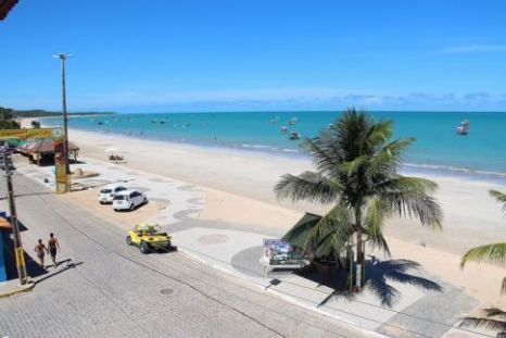
photo by Marinelson Almeida - CC 2.0 by
Maragogi, is also practically halfway to two of the main destinations(and airports) of the northeast Brazil , such as Recife and Maceio , and relatively close to one of the most coveted beach destinations in northern Brazil: https://brazilbeachtravel.com/blog/travel- porto-de-galinhas/porto-de-galinhas "> Porto de Galinhas ( View on satellite map ), beach with which it shares good part of the landscape features .
Playa en Maragogi
photo by rosanetur - CC 2.0 by
Natural Pools
Formed among the reefs of Maragogi, three natural pools stand out, the most famous being the Welsh (which are the main and the largest in the region, see in satellite map ), they are 6 kilometers from the coast and can be reached by boat and hired tours with guides in agencies or directly on the beach, in these pools you can snorkel or dive between waters crystalline, coral and colorful fish. As in Porto de Galinhas schedules to enjoy this trip are limited by the state of the tide , which should be low , so that those who want to make the trip independently of agencies should control the state of the tide, also as the schedule is limited in high season the surroundings of the pools are overcrowded with boats and it is important to note that there is a daily limit of visitors, which means that in high season it is better to hire the Welsh tour in advance.
Maragogi
photo by Marinelson Almeida - CC 2.0 by
Table of Tides
In the following link we can see the states of the tide for each day:
Maragogi
photo by guilherme jofili - CC 2.0 by
http://www.maragogionline.com.br/tabua.htm
Maragogi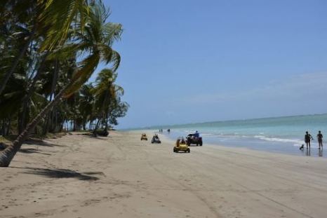
photo by rosanetur - CC 2.0 by
Beaches of Maragogi
There are more than 20 kilometers of beaches in Maragogi, going north the type of beach is the most representative of the classic Northeast landscape: palm trees, natural pools and calm sea with reefs.
Maragogi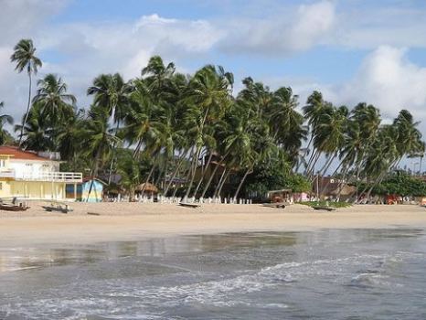
photo by Tiago Leite - CC 2.0 by
To the south, some colorful cliffs on the calm beaches of Japaratinga, and the mouth of a river on the end of the beach of Boqueirão.
Praia de Maragogi ( View on satellite map )
The most central, has a kind of rambla, and quite structure, bars and restaurants, is not the best in terms of landscape and may even be that the water is somewhat polluted to bathe.
Praia do Xaréu ( View on satellite map )
At low tide it is possible to walk in the sea towards the reefs, it is a calm beach, with crystal clear and warm waters, and very gentle at low tide.
Praia de Barra Grande ( View on satellite map )
Very nice, barracks infrastructure to drink or eat, natural crystalline pools at low tide.
Praia do Dourado ( View on satellite map )
Towards the north of Maragogi, Praia do Dourado is a small beach lined with palm trees, for those who seek tranquility and do not care about the infrastructure.
Praia do Burgalhau ( View on satellite map )
It does not have too much infrastructure, but it is one of the most beautiful and quiet of Maragogi, good for water sports with calm and crystal clear sea.
Walk to Japaratinga
8 km from Maragogi is Japaratinga( See on satellite map ), nice town with calm waters beach.
Playa do Boqueirão ( View on satellite map )
It is located towards the south of Maragogi, in the neighboring Japaratinga, some colorful cliffs between the native vegetation differentiates it from most of the beaches of the region, very quiet, coconut palms and white sand and a river that passes behind and ends at the end of the beach.
How to get to Maragogi
Maragogi is 125 kilometers north of Maceio , who arrive through Maceio airport( See on satellite map ), you can take a bus from the company Real Alagoas, which makes the route from Maceio to Recife.
Those arriving from Recife airport( See in satellite map ) can make the trip in the same bus company Real Alagoas to Maceio.
By omnibus from Porto de Galinhas
From Porto de Galinhas( View on satellite map ) you can reach Maragogi by going to the town of Ipojuca ( View on satellite map ) and from there combine to Maragogi( View on satellite map ).


Sections
Copyright
The articles published on this website are the intellectual property of their respective authors, who reserve all rights to them.
The images contained in this site are subject to the respective license and accreditation that accompanies them.
This website use Cookies Learn More